Experiences on the voyage of the First Fleet
Experiences on the voyage of the First Fleet
Journey of Bungaree and Matthew Flinders to circumnavigate Australia
Matthew Flinders & Bungaree
Source: A Voyage to Terra Australis — Volume 1 by Matthew Flinders
Author: Matthew Flinders
Link: A Voyage to Terra Australis — Volume 1 by Matthew Flinders | Project Gutenberg
Source type: Primary source (based on Flinders’ journals and observations recorded during his voyage, 1801–1803)
Useful for:
-
The circumnavigation of Australia
-
The journey of Bungaree and Matthew Flinders
-
Mapping and exploration of the Australian coastline
-
Understanding how maps were created from first-hand observations
About
Matthew Flinders commanded the Investigator and led the first successful circumnavigation of Australia between 1801 and 1803. His published account, A Voyage to Terra Australis, is based on his journals and provides detailed descriptions of the journey, including navigation, mapping and encounters along the coastline.
An important member of the voyage was Bungaree, an Aboriginal man from the Sydney region who acted as an intermediary between the crew and Aboriginal Peoples encountered during the expedition. Bungaree’s knowledge and presence helped facilitate communication and contributed to the success of the journey.
This source is especially useful for Stage 2 because it allows students to examine how the journey around Australia was recorded and how these observations were later used to create accurate maps. It also highlights the role of both European explorers and Aboriginal people in connecting Australia to the wider world.
Why this is an excellent primary source
-
It is a first-hand account written by the explorer during the voyage
-
It provides detailed evidence of navigation, mapping, and daily life at sea
-
It directly supports understanding of how Australia was circumnavigated, and knowledge of the coastline was recorded and refined
-
It highlights the contribution of Bungaree as an Aboriginal intermediary
-
It connects written records to maps as visual evidence of the journey

Portrait of Matthew Flinders, RN, 1774–1814 by Toussaint Antoine De Chazal De Chamerel

Copy of a page from the diary of Matthew Flinders.
~
Source: The Sydney Gazette and NSW Advertiser, 12 June 1803
Author: Matthew Flinders
Link: p4 - 12 Jun 1803 - The Sydney Gazette and New South Wales Advertiser (NSW : 1803 - 1842) - Trove
Why this is an important primary source
-
It is a first-hand account from 1803, created during the voyage
-
Combines:
-
personal observations (letter)
-
practical navigation knowledge (directions)
-
colonial reporting (ship news)
-

~
What this source is about
This source is a newspaper publication from the Sydney Gazette, 12 June 1803, featuring a letter written by Matthew Flinders during his voyage on HMS Investigator.
The article contains three key sections:
1. Flinders' letter to the Governor
-
Written during his circumnavigation of Australia
-
Describes:
-
the progress of the voyage
-
coastal observations
-
navigation challenges
-
-
Provides insight into how Flinders reported his findings to colonial authorities
2. Directions for sailing the Torres Strait
-
Practical navigation instructions based on Flinders’ observations
-
Includes:
-
routes through Torres Strait
-
hazards and safe passages
-
-
Shows how knowledge from exploration was turned into usable guidance for sailors
3. Ship News
-
Provides an outline of Flinders' journey in The Investigator to date.
-
Shows how information moved from: exploration → written report → publication → public knowledge
-
Demonstrates how voyages contributed to safer navigation and improved mapping of Australia
-
Provides evidence of the importance of communication in the colony
Map: General chart of Terra Australia by Matthew Flinders, 1804
Source: National Museum of Australia
Link: Flinders circumnavigates Australia | National Museum of Australia
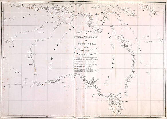
What this map shows
-
The full journey of HMS Investigator around Australia (1801–1803)
-
The route taken by:
-
Matthew Flinders
-
Bungaree
-
-
Key exploration areas:
-
South coast
-
Gulf of Carpentaria
-
East coast return to Sydney
-
This map is taken from the National Museum Australia's article, "1801–03: Matthew Flinders leads voyage circumnavigating the continent he names ‘Australia’: This voyage was the first complete circumnavigation of Australia.
This chart was published in 1804, a year after Flinders circumnavigated Australia. The continent's true shape was shown for the first time.
General chart of Terra Australia by Matthew Flinders.
~
Links & sources: See captions
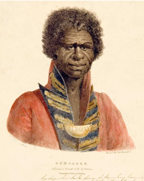
Images: Bungaree, Chief of the Broken Bay tribe

~
Source: Sydney Gazette and NSW Advertiser, 11 August, 1826 - 11 Aug 1826 - Domestic Intelligence. - Trove
"DOMESTIC INTELLIGENCE.
WE are much gratified in being able to state, that Mr. Earle, the Artist, has at length succeeded in producing several excellent specimens in Lithography. Among them, is a representation of the well-known Native Chief of Sydney, Bungaree, which, we understand, is intended for sale, and, as usual with Mr. Earle, at a very low price.
As a first attempt of the kind in the Colony, it has been dedicated to General Darling. The likeness is faithful —and, considering the difficulties. Mr. Earle has had to contend with, great credit is due to that gentleman."

What these images show
These portraits typically show Bungaree:
-
Wearing European military-style clothing and a gorget (king plate)
-
He is depicted as a cultural intermediary and someone moving between Aboriginal society and colonial society
This is powerful evidence of interaction between cultures and Bungaree’s role in exploration
Why these images are excellent primary sources
-
They are created during Bungaree’s lifetime (early 1800s)
-
Show how he was viewed by Europeans
-
Provide visual evidence of identity, status, and cross-cultural contact
Images: From the volumes of Matthew Flinders

View of Port Jackson taken from the South Head

View from the south side of King George's Sound.
~